What is measured, and where · Observed State
This map does not say what is happening today. It says where the instruments are: the 30 air corridors and the 52 countries whose connectivity is measured.
The circles are to scale. They are not all the same size because the real radii are not: they run from 71 to 250 nautical miles. A corridor is not an airport, it is a region.
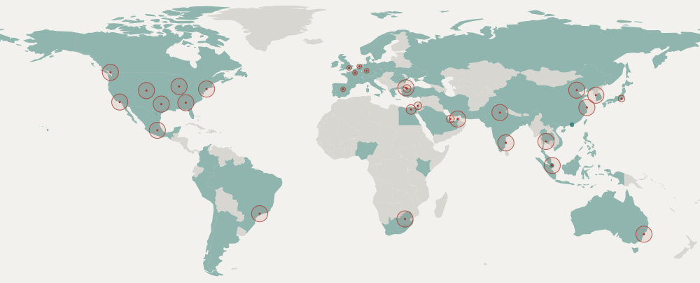
The 30 air corridors
On the right, the radius in nautical miles around the point.
- Amsterdam71.63
- Atlanta250
- Bangkok250
- Beijing250
- Cairo150
- Chennai250
- Chicago250
- Dallas250
- Delhi250
- Denver250
- Doha120
- Dubai250
- Frankfurt71.63
- Istanbul250
- Istanbul Sabiha120
- Johannesburg250
- London71.63
- Los Angeles250
- Madrid71.63
- Mexico City250
- New York250
- Paris71.63
- Sao Paulo250
- Seoul250
- Shanghai250
- Singapore250
- Sydney250
- Tel Aviv120
- Tokyo100
- Vancouver250
The 52 countries for connectivity
- Argentina
- Australia
- Austria
- Bangladesh
- Belgium
- Brazil
- Canada
- Chile
- Colombia
- Czech Republic
- Denmark
- Egypt
- France
- Germany
- Greece
- Hong Kong
- India
- Indonesia
- Iran
- Ireland
- Israel
- Italy
- Japan
- Kenya
- Malaysia
- Mexico
- Netherlands
- Nigeria
- Norway
- Pakistan
- People's Republic of China
- Peru
- Philippines
- Poland
- Portugal
- Romania
- Russia
- Saudi Arabia
- Singapore
- South Africa
- South Korea
- Spain
- Sweden
- Switzerland
- Taiwan
- Thailand
- Turkey
- Ukraine
- United Arab Emirates
- United Kingdom
- United States of America
- Vietnam
And what is not measured
The map reads just as well for what it leaves grey. There is not one air corridor in continental Africa, none in South America except São Paulo, none in central Asia. Connectivity covers more countries, but it too leaves out almost all of Africa.
This is not an oversight waiting to be fixed: every new source costs two or three alarms a month and one more row on a front page that already has twelve. What the map shows is where this system can say something and where it cannot, which is exactly what you need to know before believing any of it.
← Back to the index